What is the Watershed District?
The Swan Lake Watershed District (SLWD) is a municipally-based, non-profit organization made up of local people in partnership with the provincial government, private industry, and non-government organizations.
The Watershed District's co-operative mandate is to promote the sustainable use and management of land, water, air and related resources within the Watershed District boundary.
The Watershed District's co-operative mandate is to promote the sustainable use and management of land, water, air and related resources within the Watershed District boundary.
Where is the Watershed District?
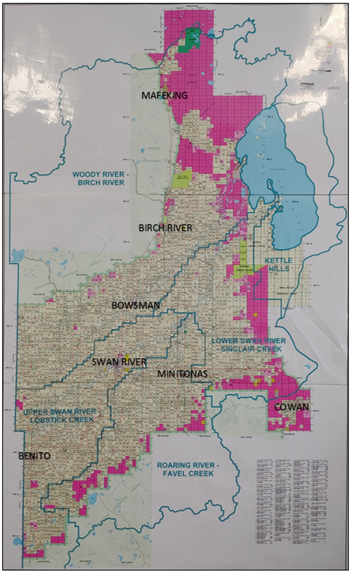
The SLWD office is located in Swan River, Manitoba, with its boundaries currently including the following:
- Municipality of Swan Valley West;
- Municipality of Minitonas-Bowsman;
- RM of Mountain; and
- Town of Swan River
Who operates the District?
The SLWD is governed by a Board of Directors comprised of municipally-appointed members, with significant input by sub-district members representing grassroots level people.
The SLWD employs a full time Manager, Administrator, Resources Technician, and hires seasonal employees during the summer months.
The SLWD employs a full time Manager, Administrator, Resources Technician, and hires seasonal employees during the summer months.
What does the landscape look like?
The SLWD was formed in 2006, with programming starting in 2007. The Watershed District is one of the most topographically diverse watersheds in Manitoba and covers an area of approximately 4,200km2.
The SLWD is one of many watersheds that contribute to the greater Lake Winnipegosis and Lake Manitoba Basins. Soils in the lower portions of the Swan River Valley, along Swan Lake, are mostly lacustrine, meaning they were formed by glacial lake deposits and consist of layers of clay, silt and sand. Along the base of the Porcupine Hills and south of Swan Lake sand was deposited by the ancient beaches of Lake Agassiz.
Topographically significant features of the watershed include the Porcupine Hills, Duck Mountains, Thunder Hill, Kettle Hills the Swan River Valley, and the Swan Lake Plain.
The two major rivers run parallel to each other, the Woody and the Swan River. Both of the rivers originate in Saskatchewan, flowing across the border into Manitoba and eventually into Swan Lake. Other rivers of the watershed, that comprises the sub-watersheds within the Watershed District, include the Birch, Roaring, Sinclair, West Favel and East Favel rivers. The Bell and Steeprock rivers are also located within the Watershed District area; however, they are located north of Swan Lake and do not drain directly into Swan Lake.
The Watershed is home to approximately 10,000 residents and supports recreational tourism, agriculture, forestry and commercial fishing.
Meet the Main Board
*Members on the Main Board are effective from January 2024 - January 2025 and are re-elected each year.*
Meet the Sub-District Members
*Members on the Sub-District Boards are effective from January 2024 - January 2025 and are re-elected each year.*
|
Roaring River/Favel Creek Sub-District members include:
Upper Swan River/Lobstick Creek Sub-District members include:
Lower Swan River/Sinclair Creek Sub-District members include:
Woody River/Birch River Sub-District members include:
Provincial Appointee:
|
If you have a project that is related to land and water management that would be beneficial for the environment, let us know or contact any of the members you see above! We would be glad to assist you!
Board Meeting Minutes
*Coming soon*
